


Arctic Air Mass to Bring May Freezing Temperatures
- Isaac Cleland
- May 7, 2020
- 3 min read
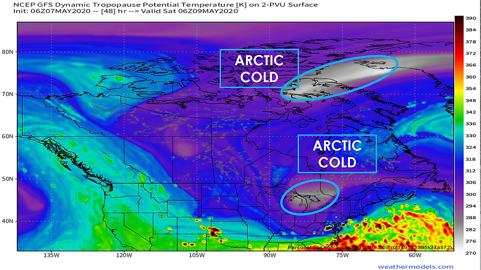
An unusually strong surge of arctic air is heading for the Great Lakes this weekend. Believe it or not, this is actually a piece of the Polar Vortex dislodging from its normal position in the arctic. I know this term has been discussed recently, particularly during the winter, but in this case, the arctic air-mass is plunging south in early May. You can see how a small piece of the vortex becomes detached from where the core of the arctic air is normally located and then dives south into the Great Lakes. Since it is May, of course, it won't be as cold as it would be in January or February, but relative to typical May weather, this will be extremely cold and will deliver a late season hard freeze, which could result in damage, perhaps severe in some cases, to early season crops, and especially fruit trees.
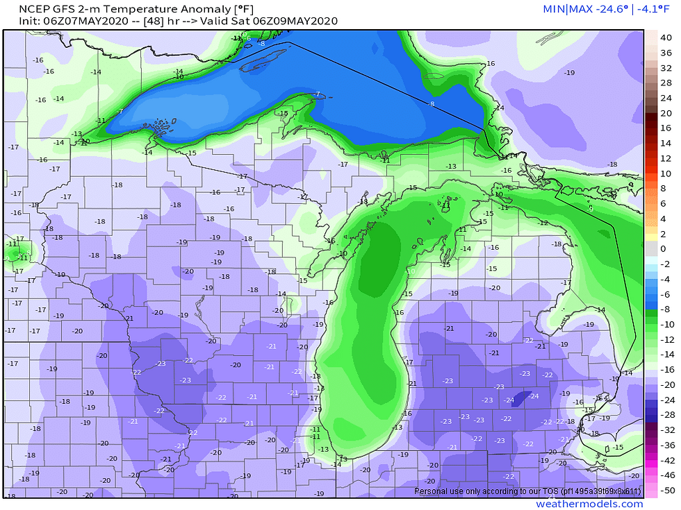
This air-mass will bring temperatures as cold as 15-25 degrees below normal to mid-Michigan, with the core of the coldest air on Saturday morning. Let's put this into perspective. The normal high for Saturday, May 9th in Lansing is 67 and the normal low is 44. Subtract 20 from this and you get highs in the 40s and lows in the 20s. In January, a similar air-mass would send temperatures below 0 at night and highs in the single digits to near 10. In fact, if you remember late January of 2019, a weather pattern similar to this one brought wind chills near -30. The difference now is the time of year and the impacts will be different as well.

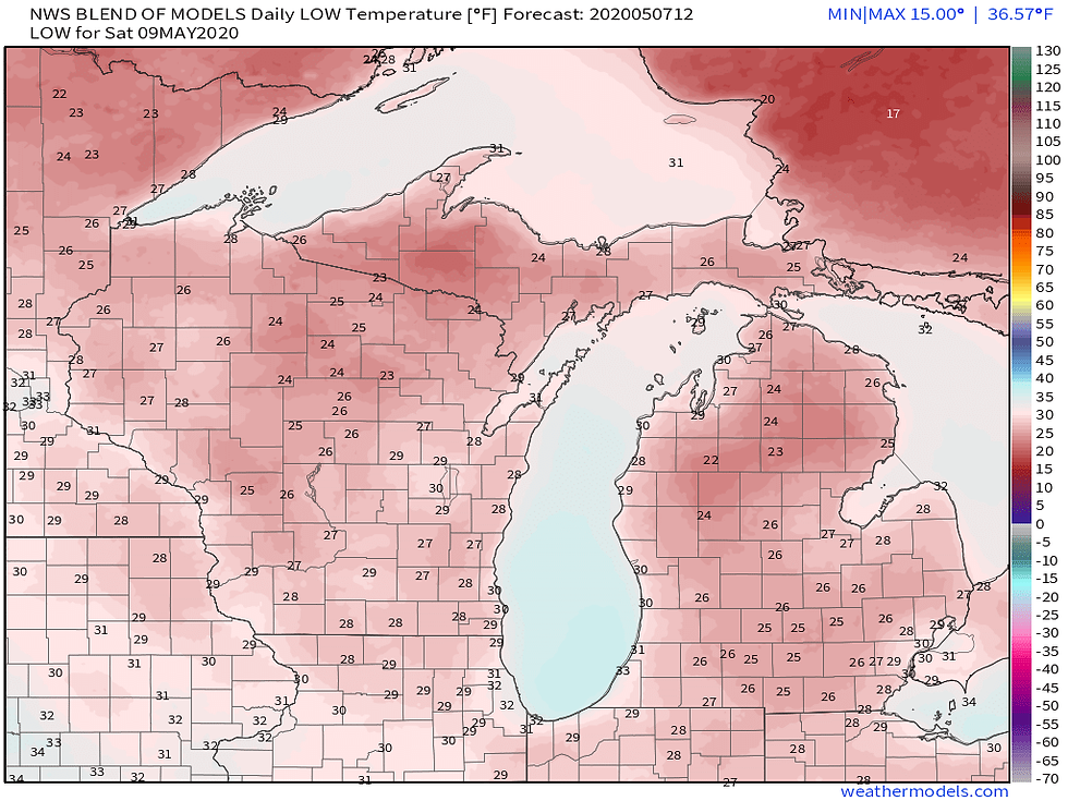
Near Record Lows will be possible this weekend and although the coldest air is out of here after Saturday morning, the cold will linger into early next week. All these records are rather old. In fact, the record low of 25 for Lansing on May 9th occurred all the way back in 1868, right around the time when records began being kept for Lansing. Compare that record to forecast lows Saturday morning below:
These nights of lows in the 20s and 30s looks to continue all the way through Tuesday if not Wednesday of next week. The record low of 28 on May 12th may be a close call on Tuesday morning.

The main concern with freezing temperature so late during the spring is possible damage to early season vegetation. The most vulnerable vegetation will be fruit trees that have already bloomed. The extent of damage that may occur depends on how far along the trees are and whether or not they have bloomed, but at this point I suspect many if not most already have. People with interests in fruit trees and other outdoor vegetation will need to be aware of how far along their trees are and take precautions to protect them from the freezing conditions. A Freeze Watch has been issued by the National Weather Service in Grand Rapids for Friday night into Saturday morning. The Freeze Watches are all in the light blue color:

This is the latest from the National Weather Service as of Thursday morning:
FREEZE WATCH IN EFFECT FROM FRIDAY EVENING THROUGH SATURDAY MORNING... * WHAT...Sub-freezing temperatures as low as 26 possible. * WHERE...Portions of central, south central, southwest and west central Michigan. * WHEN...From Friday evening through Saturday morning. * IMPACTS...Frost and freeze conditions could kill crops, other sensitive vegetation and possibly damage unprotected outdoor plumbing. * ADDITIONAL DETAILS...Early season tender vegetation will need to be protected. Most vulnerable vegetation will be fruit trees that have already bloomed.
We have a distinct possibility for frost and freezing temperatures most of the next 5 to 6 nights. Tonight there is the potential for frost with low temperatures in the middle to upper 30s. Given the time of year however, with it being early season, the threat is more towards fruit trees so we decided to hold off on a frost headline. Fruit trees need colder than the mid 30s we are forecasting to do damage. Most folks have not put out tender vegetation at this point given it is still only May 7th. So, again no frost headline for tonight. The main concern is still focused on Friday night into Saturday morning and we have issued a Freeze Watch for this time frame. Temperatures are forecast to drop into the mid to upper 20s area wide. Fruit trees in our southwest areas, from GRR to the south and west are most susceptible to the cold as these are the zones that have the furthest development. The Freeze Watch is for all zones that are currently active/in the growing season, roughly south of a line from Pentwater to Alma.
Continue Reading:
Stay up to date:
Comments